Intuitive web GIS information for all platforms and modules
Flexible in terms of time, location-independent and cross-system – data and applications are becoming available faster and more easily. Whether at your desk in the office or on the road on a tablet or smartphone, your specialised data can now be available anywhere and at any time!
Boundless possibilities: BaSYS maps visualises anything with coordinates. The browser-based web application depicts the entire wastewater network, gas and water lines, bus stops or chewing gum vending machines. Even mobile fittings, such as risers with a GPS transmitter, can share their location live in BaSYS maps. As an app, desktop installation or SaaS solution, the software is optimal for mobile use on smartphones or tablets and comes with all the functions of a modern GIS application.
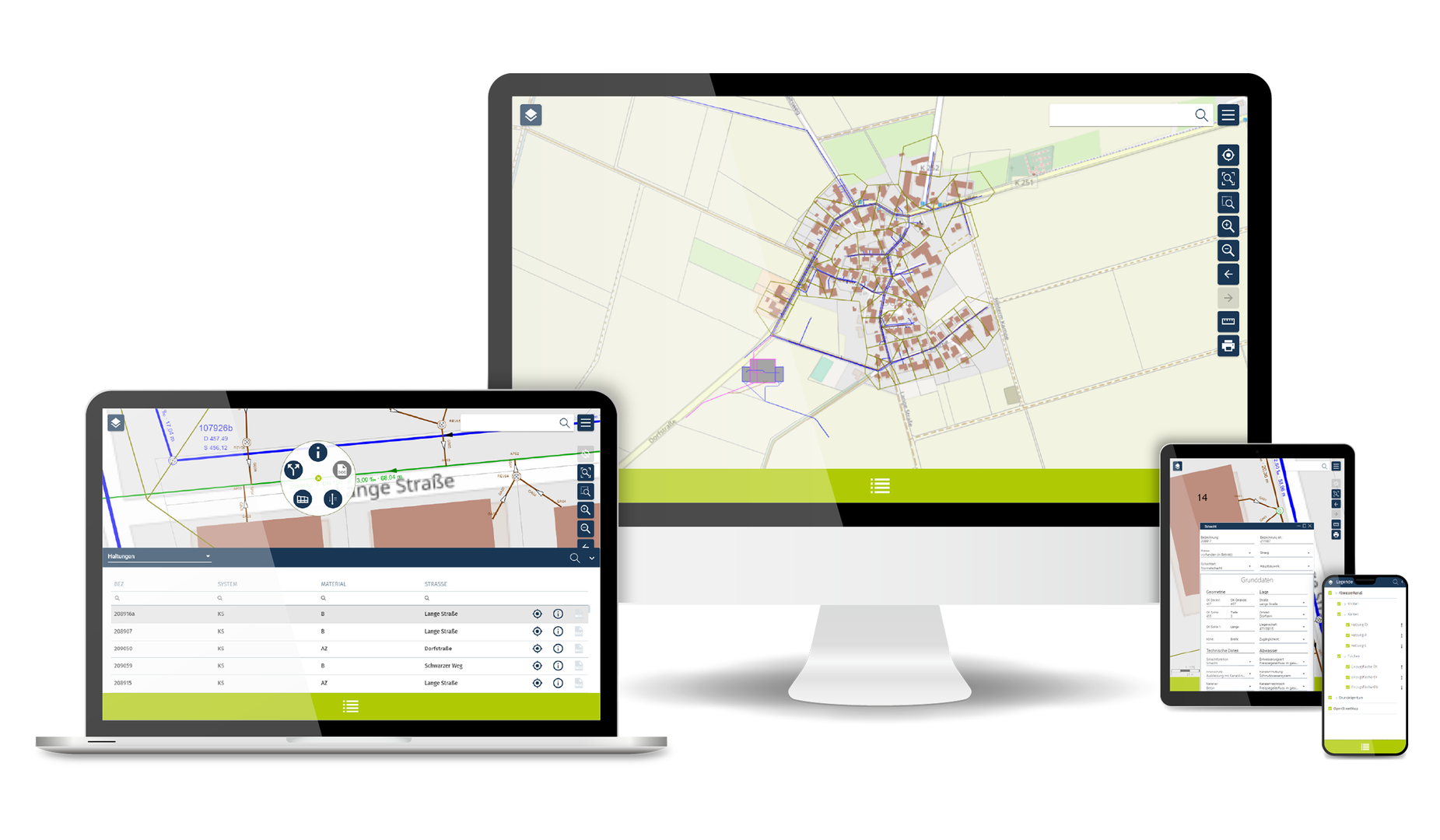
The new user interface is based on the familiar handling of the best-known applications on smartphones, tablets and websites. The self-explanatory interface is optimised for effective and goal-oriented handling of BaSYS maps. You decide whether you prefer a desktop installation, want to work in an internet browser or operate the app on your tablet or smartphone.
Developed from scratch: BaSYS maps is based on the latest technologies. Only information that is actually needed is specifically retrieved from your extensive database. Long loading times are history - you now work with fast performance. Translated with www.DeepL.com/Translator (free version)
- Browser-based web application
- Available as a desktop installation or SaaS solution
- Optimised for mobile devices: Smartphone, tablet or notebook
- GPS navigation in the map view
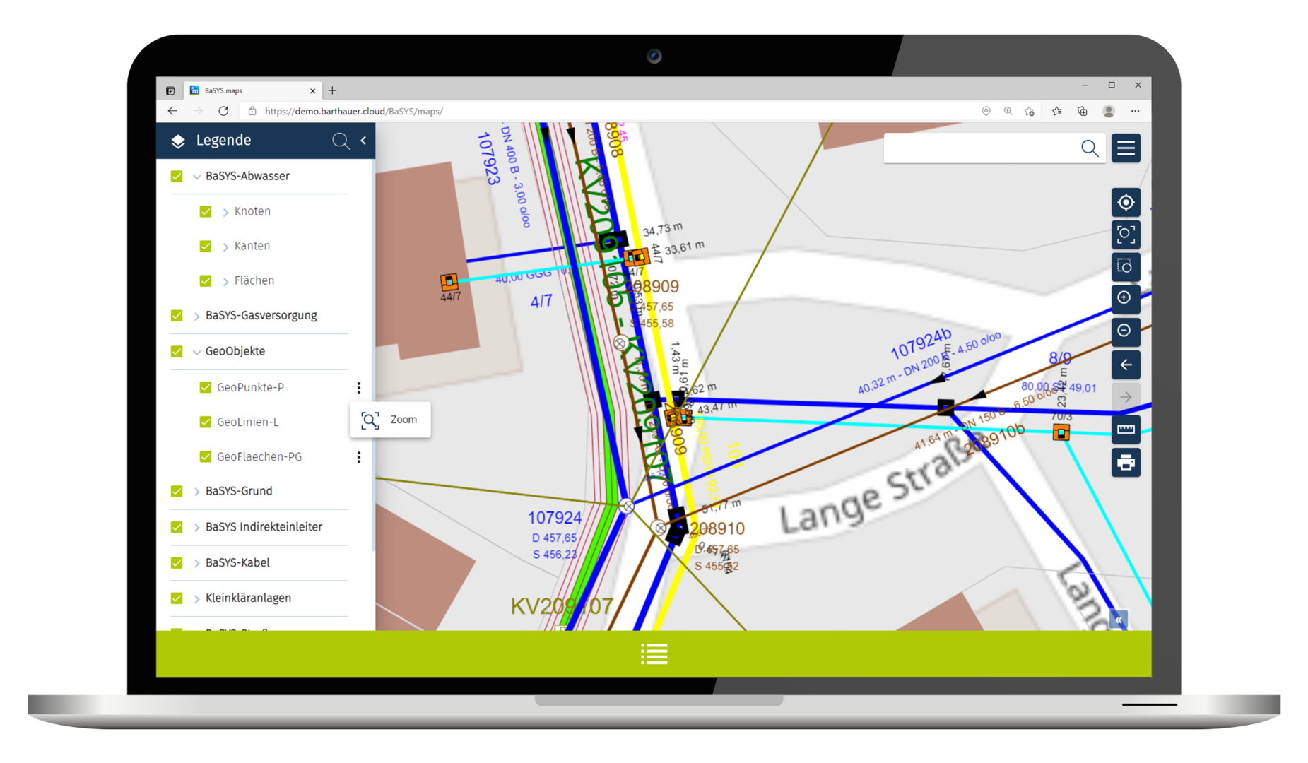
- Access object information in the list or on the map
- Zoom functions
- Print map sections
- Measure distances and areas
- Access to linked documents
- Open Street Map included by default, integration of various data source such as Shape, WMS etc. is possible via admin
One application for all
Redeveloped from the ground up: BaSYS maps is based on the latest technologies. Only information you actually need is selectively queried from your extensive data pool. The map layout is realised with a dedicated mapping service.
Hint and print
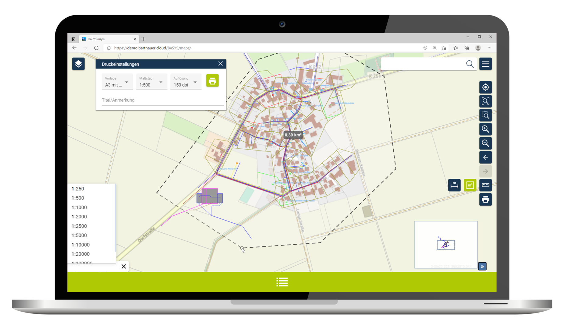
Zooming, displaying thematic maps, true-to-scale reproduction, measuring areas and distances as well as printing map sections are natural functions of modern geoinformation systems. In BaSYS maps these tools are not only available in the browser, they are also optimised for use on mobile touch devices. Operation is simple and self-explanatory: switch on, log in and get started.
Specialised information and access to documents
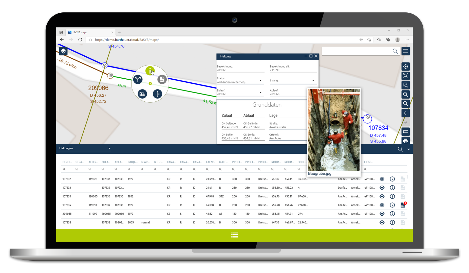
All objects recorded in the BaSYS database are displayed in the list view and can be selected individually on the map. Object information includes inventory data such as the age, material, location and condition. Assigned documents and media, such as protocols and photos, can also be viewed for the individual objects.
Wastewater module expansion
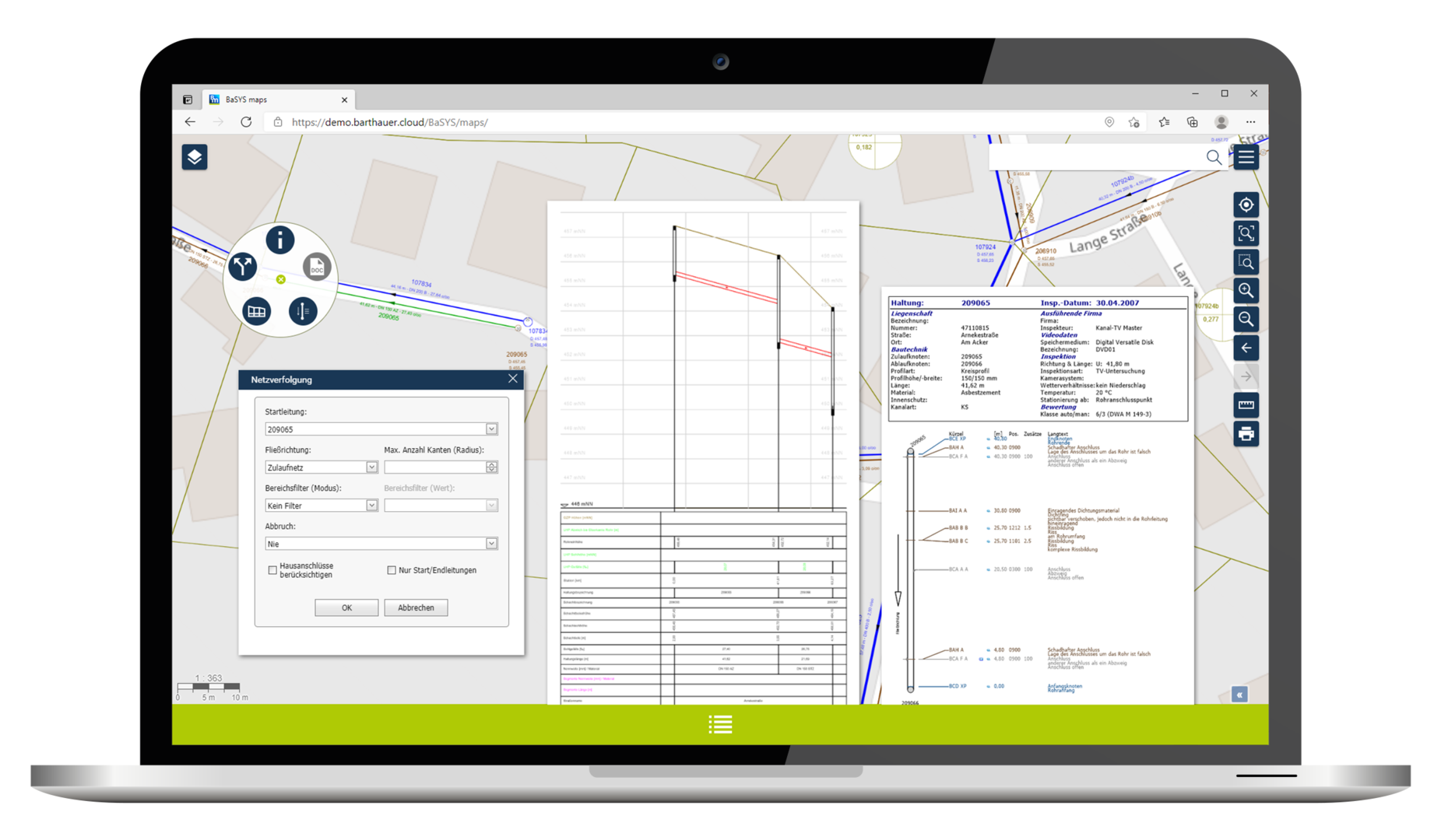
Designed as a straightforward information solution, the technical depth of the scalable BaSYS maps system is convincing. Specific additional functions are available for many different specialised applications. For example, the wastewater module offers the following:
- Configurable network tracing
- Informative longitudinal sections
- Complete pipe and manhole graphics with image and video playback for the respective inspections
Perfectly integrated
The BaSYS databases for all special fields are centrally processed and administered from one full BaSYS workstation. Individual theme plans, screen definitions and documents are available immediately. Users and profiles are administered via BaSYS – changes are published online immediately.
You need a full BaSYS workstation or the support of a BaSYS service provider.
For the installation at your site, you need:
A DB server, BaSYS DB + web server or an external hosting service provider An administrator to set up users and profiles... ...or we can do that for you.
You don’t want an installation?
We offer BaSYS maps under the SaaS model. We provide the hardware, software, security and experts.
Our servers for the Barthauer Cloud are not offshore, but located in Frankfurt am Main, directly at the DE-CIX as the world’s largest Internet node. The entire IT infrastructure is designed with full redundancy and meets the highest quality and security standards. Certificates and technical details are available on request.
Certified according to: ISO/IEC 27001:2013, ISO 9001 Quality Management, PCI DSS (Payment Card Industry Data Security Standard, T(ier)3+ Standard, TÜV Saarland ISO/IEC 27001, IT Security "VdTÜV Basic Guideline Green Electricity Products" of Merkblatt Energie 1304 Version 10.2014, 100 % green electricity supply in regular operation, TÜV SÜD.
Analogous to the price models of our client software, we also offer individual solutions for BaSYS maps. From a monthly usage fee of €60 (plus set-up costs), you have access to an information station. We offer the following models:
On Premises
You purchase the software for one or more accesses. The installation takes place on your premises.
SaaS
You rent the software, the installation takes place in our cloud. Regular updates, maximum security, access and data storage can be expanded at any time.
Are you curious?
Our sales team will be happy to provide you with further information about BaSYS maps. Send us an email, call us at +49 531 23533-10 or use the contact form and we will get back to you.